


A Southwest Airlines Boeing 737-700, registered N247WN, sustained substantial damage after encountering hail and turbulence during initial descent toward Nashville International Airport (BNA), Nashville, Tennessee, on May 2, 2025, at about 1200 local time. The Part 121 scheduled flight was operating from Austin-Bergstrom International Airport (AUS), Texas, to BNA. Damage was reported to the leading edges of the wings and the horizontal stabilizer. None of the 149 occupants were injured, and the flight continued to BNA without further incident.
According to the published information, thunderstorm activity was forecast for the flight’s arrival into the Nashville area. The flight crew monitored weather approaching the airport using a weather application on an electronic flight bag and planned a deviation to the north to avoid the observed weather. As the airplane passed the Memphis area, the captain requested that flight attendants be seated earlier than normal in case turbulence was encountered.
Before the weather encounter, the flight was descending from flight level (FL) 360 toward FL240. The crew reported that conditions were clear air and that a cloud build-up was visible at about the 1 o’clock position. Air traffic control also advised of “a cell” at the 12:30 to 1 o’clock position. After reviewing the onboard weather radar and the electronic flight bag weather application, the crew reported that those sources did not show indications of weather directly ahead of the airplane.
As the descent continued, the crew observed a flat stratus layer below and ahead, without visible buildups. ATC subsequently advised the flight of moderate to extreme precipitation at the 12:30 to 1 o’clock position. The crew associated that advisory with the cloud build-up that had been visually observed at approximately the 1 o’clock position earlier in the descent.
The airplane entered clouds at about FL320. The crew described the initial ride as smooth with occasional light chop. While at FL280 and 290 knots, the flight suddenly encountered precipitation and turbulence. The captain reported the rainfall as very heavy and stated that the noise level suggested hail, though the hail could not be visually confirmed at the time. In response, the captain retarded the throttles and deployed the speed brake to slow to turbulent air penetration speed.
After about one minute, the heavy precipitation ended. The airplane leveled at FL240 and remained in instrument meteorological conditions. The crew reported moderate turbulence to ATC and continued the flight to BNA. Post-event assessment found hail-related damage to the leading edges of the wings and the horizontal stabilizer, with photographs documenting damage on the right wing leading edge and the left horizontal stabilizer leading edge.
Weather records reviewed for the event included Convective SIGMET 99C issued at 1155 by the National Weather Service Aviation Weather Center for an area of severe embedded thunderstorms moving from 250 degrees at 40 knots with maximum tops above FL450. The SIGMET stated that hail up to one inch in diameter and wind gusts to 50 knots were possible with the storms. A severe thunderstorm watch had also been issued earlier that morning for a line of severe thunderstorms moving across Tennessee.
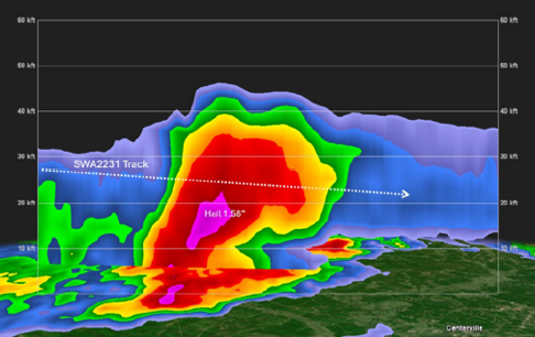
Radar data described in the published information showed the flight track passing through an area of extreme intensity echoes. The referenced WSR-88D base reflectivity imagery near 1202 local time indicated echoes up to 65 dBZ at lower elevation scans and 58.5 dBZ at the airplane’s flight level. The severe hail algorithm indicated hail to 1.58 inches in the vicinity of the flight track during the period, and echo tops were described as reaching FL446.
The published information stated that the reason the severe weather shown in radar imagery was not depicted by the onboard weather radar system or the electronic flight bag weather application was not determined. The first officer did not recall the onboard radar tilt setting(s) used at the time, and onboard radar imagery was not recorded. In addition, the operator was described as having no means to replicate which imagery was available to, or used by, the flight crew from the weather application.
Operational limitations of airborne weather radar were cited from an aviation weather handbook, including attenuation effects that can create a radar “shadow” when a cell absorbs or reflects radio signals, potentially preventing detection of additional cells behind it. The handbook material also noted that while hail gives a radar echo, hail may fall several miles from the nearest visible cloud, and hazardous turbulence may extend to as much as 20 miles from an echo edge. The published information further stated that the severe weather may not have been depicted due to radar limitations or specific settings (such as tilt and range), rapid development and/or movement of severe weather, latency in application data, or other factors, and that there was insufficient evidence to determine whether any of those characteristics were a factor.

